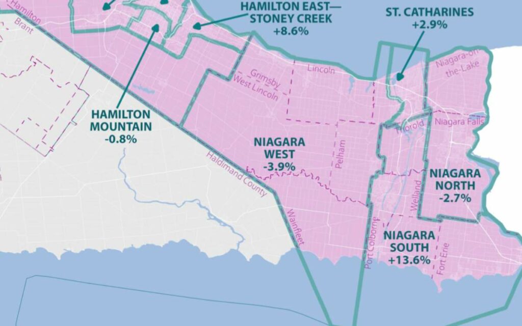
As initially proposed back in August 2022, Fort Erie would exit the current riding of Niagara Falls, while the newly formed district of ‘Niagara South’ would become the peninsula’s most populous riding. Photo credit: Federal Electoral Boundaries Commission for Ontario
Back in August 2022, the three-member Federal Electoral Boundaries Commission for Ontario proposed a number of adjustments to the province’s current electoral map, including several changes in Niagara.
The proposed modifications were made in response to Ontario’s significant population increase from 2011 to 2021, and account for the allocation of one additional district.
After releasing its initial recommendations, the Commission accepted written submissions and held two public hearings in September and October to field feedback about the Niagara changes.
“The time and effort committed by the public to this important democratic process was remarkable and very much valued by the Commission,” said Justice Lynne C. Leitch, chair of the Commission. “We are satisfied that we have balanced our statutory obligations with the views of the people of Ontario, striving for the goal of effective representation.”
After taking the public’s feedback into account, Leitch and her colleagues updated their realignment and tabled the resultant report in the House of Commons on February 10, where it’s now under consideration by MPs.
If the Commission’s updated realignment remains unchanged, the current electoral district of Niagara Falls would no longer include the municipality of Fort Erie, as originally recommended back in August.
However, unlike as proposed in the summer, the district would not retain its present name and instead be called “Niagara North”. Niagara North, according to the Commission’s tabled report, is a “more inclusive descriptor” given that the district is set to include both the City of Niagara Falls and Town of Niagara-on-the-Lake.
Based on data from the 2021 census, Niagara Falls is Ontario’s fifth most populous electoral district. With 146,404 residents, the riding currently deviates 25.6 per cent above the advised electoral quota of 116,590.
With the removal of Fort Erie, the riding’s population would fall to 113,503, 2.7 per cent below the commission’s target figure.
Despite a reported submission by an “elected official” calling for Fort Erie to remain connected to Niagara Falls and Niagara-on-the-Lake, the population quota necessitated the town of over-30,000 be moved to “Niagara South” alongside the municipalities of Port Colborne, Welland, and Thorold.
Back in August, the Commission recommended half of Thorold north of Highway 20 be included in Niagara West but changed direction after community feedback.
“It was stated that the importance of the Welland Canal to the community identity of Thorold, both historically since Confederation and currently, cannot be underestimated,” reads the report. “The Commission concluded that the demonstrated north/south economic development resulting from the canal communities’ aligned representation should be preserved.”
Niagara South would boast a population of 132,396, 13.6 per above the electoral quota, making it the most populous district on the Niagara Peninsula.
The current electoral district of St. Catharines would remain largely intact, gaining about 5,000 residents with the dissolution of Niagara Centre, despite losing more population to Niagara West. Based on the proposed changes, St. Catharines would be the second most populous riding in Niagara at 119,977 residents, 2.9 per cent above quota.
As a result of public consultations, it was determined that the entire Brock University campus be kept intact under a single district. Therefore, a small section of northern Thorold was moved into St. Catharines for the updated report, “as it was clear that the orientation of the University was toward this district and to the City of St. Catharines.”
Finally, Niagara West underwent the most dramatic change from its original realignment proposed last summer, where it was recommended the district include half of Thorold and a significant portion of southeast Haldimand County, including the community of Dunnville. It was also recommended Niagara West lose the part of Grimsby lying north of the Niagara Escarpment to Hamilton East—Stoney Creek.
Objections from the public reversed all of the above.
“It was argued that Thorold’s industrial and urban nature made it a better fit with the Welland Canal communities rather than the rural and agricultural communities in Niagara West,” reads the report. “Arguments were also made that the interests of Dunnville are better aligned with other communities along the Grand River than with those of Niagara West, and that the boundary between Haldimand County and the Township of Wainfleet should be respected as much as possible.”
The population of the newly proposed Niagara West would be 112,065, 3.9 per cent below the Commission’s target number.
Under the Electoral Boundaries Readjustment Act, the advisory panel’s main goal was to divide the province into 122 electoral districts that are as close to the “electoral quota” as reasonably possible, while factoring in communities of interest or identity and historic and geographic concerns.
Calculated by dividing the province’s current population by the number of ridings, Ontario’s current electoral quota per district is 116,590, up more than 10,000 residents per riding from a decade ago.
The last federal electoral redistribution took place in 2012.
Outside of a few ridings in Ontario’s far north, the federal redistribution will automatically realign the province’s provincial ridings to conform to the new boundaries for the 2026 election.
Commissions in Canada’s other nine provinces are currently working on readjusting their respective jurisdictions’ electoral districts to most closely align with prescribed quotas.
The finalized new representation order is scheduled to be announced in September 2023. However, changes to the electoral boundaries will not come into effect until Apr. 1, 2024, at the earliest.
Canada’s next federal election must take place on or before Oct. 20, 2025. Ontario’s next provincial election is scheduled for Jun. 4, 2026.